Sunday, 10 p.m.
Additional atmospheric rivers are forecast to impact Skagit County, bringing more rain tonight through tomorrow, with another system expected on Tuesday. These storms may cause additional flooding as the Skagit River once again approaches near-record levels.
Based on the latest analysis, these developments are not expected to significantly impact the Swinomish Reservation or the town of La Conner at this time. We deeply appreciate the Swinomish Indian Tribal Community’s emergency management team for their close monitoring and detailed analysis, which continue to inform local planning and response.
However, we are not in the clear.
Main concern: high winds and power outages
The most significant threat for both La Conner and Swinomish right now is high wind with peak gusts of 40–50 mph expected to accompany tomorrow’s rain.
These winds can bring down trees and structures already weakened by saturated ground.
There is an elevated risk of power outages. Please secure loose outdoor items, charge devices, and have flashlights and backup batteries ready.
Traveling east toward Burlington and Mount Vernon is still not recommended. If you must travel, use extreme caution. Check current road closures and detours before you leave.
Expect changing conditions, standing water, and debris on the roads. If you encounter flooded roadways, downed trees or power lines, or other unmarked hazards: TURN AROUND – do not drive through. Then report the incident and location to 911.
We’re moving through another risky stretch of weather. Levee systems, soils and trees are all stressed from the past week of storms.
Please stay tuned to official updates from Swinomish, the Town of La Conner and Skagit County.
Avoid unnecessary travel, especially at night or during peak wind.
Check on neighbors, elders and those with mobility or medical needs.
Saturday, 4:34 p.m.
Skagit County is still in full emergency response mode as crews monitor damaged levees, high river flows and widespread flooding — and now another atmospheric river with high winds is on the way. The next storm is expected to arrive Sunday evening, bringing the potential for moderate to major flooding early next week.
With the river projected to stay near or above flood stage into late next week, the county’s Emergency Operations Center remains activated around the clock, and residents are being urged to stay alert as conditions evolve.
Response and staffing
Roughly 300 National Guard members are now deployed in Skagit County, working alongside hundreds of local first responders in the field and at the Emergency Operations Center. Officials say these staffing levels are expected to hold through the next weather system starting Sunday night.
Levees and dams are still being monitored and shored up. Several have been reinforced with additional rock and gravel, and dam operators are beginning to draw reservoirs down where possible to make room for incoming flows.
BNSF has reopened the north–south rail line through Skagit County and will continue to monitor track conditions and reassess if needed.
Evacuations and returning home
In a Friday 7 p.m. update, Skagit County told residents they may return home if roads are safe in their neighborhood.
The county is urging people to:
- Turn around, don’t drown – do not drive through water over roadways.
- Avoid walking or wading through standing floodwater, which may be contaminated or hide hazards.
Federal help: Stafford Act approved
The Stafford Act disaster declaration has been approved, which allows Skagit County Emergency Management to tap into additional federal resources and support for response and recovery.
Officials say a top priority in the coming days will be the reopening of medical facilities and local businesses. Areas will be cleared to reopen only after they’re evaluated and deemed safe from continued flood danger.
Shelters, pets and donations
A current list of shelters, including locations that can help with pets and livestock, is available at www.skagitcounty.net/flood
Shelter guests are encouraged to call ahead to confirm availability and capacity before traveling.
The county is not coordinating centralized volunteer efforts at this time. Anyone wanting to volunteer or donate is asked to work through local nonprofits and service organizations.
Temporary Flight Restriction: no personal drones
One urgent reminder: a Temporary Flight Restriction (TFR) is in effect over the affected area.
That means:
- No personal drones are allowed to fly in the restricted airspace.
- When hobby drones go up, emergency drones have to stand down.
Those aircraft are being used for search and rescue, life safety, damage assessment and flood response. Unauthorized drones interfere with those missions and put both responders and residents at risk.
Friday, 11:30 a.m.
Governor Bob Ferguson announced that President Trump has signed his request for an emergency declaration, authorizing the Federal Emergency Management Agency to provide aid to the affected areas.
Friday, 10:41 a.m.
The Skagit County Department of Emergency Management special webpage for flood information is down for at least the second time since Wednesday. Go to the Town of La Conner’s website for official updates follow La Conner Community News for regular news briefings.
On Friday morning, La Conner remained generally unaffected by the flooding taking place upriver in the Skagit Valley, though the risk of flooding remains as the rains continue and Skagit River continues to swell and put pressure on dikes and levies.
The Town reiterated that they have not called for an evacuation here. Skagit County has urged evacuation since Wednesday, causing confusion among residents about what to do. Town officials say La Conner’s flood risk is different from neighboring areas, even those in the floodplain. To flood La Conner, the Skagit River would have to break through a dike and travel several miles across farmland before reaching town, which could take hours.
Presently, the dikes and levees are holding and made it through the night intact, according to the incident management team coordinating with local authorities.
Elsewhere, Burlington experienced some flooding overnight and Fir Island is still closed and likely to remain closed for the day. Most of the flooding appears to be coming from overflowing water on Highway 20.
Thursday, 2:41 p.m.
Moving vulnerable residents is one of the hardest parts of disaster response, and La Conner is feeling that now: the La Conner Retirement Inn has begun a full evacuation ahead of potential flooding.
Radiant Senior Living, which owns and operates the inn, is relocating remaining residents to The Village Senior Living in Tacoma. Many residents have already left with family or friends; as of late morning, there were four independent-living and eight assisted-living residents still waiting to be transported.
“It’s been a really busy morning,” said Jenni Bost, vice president of sales and marketing for Radiant Senior Living. Staff at the inn were focused on “ensuring a smooth evacuation and minimizing stress” for residents, she said.
The Retirement Inn had an emergency plan in place. “When the town started sharing updates, that started the first phase of the plan. When the evacuation order came out, we shifted to that,” Bost said. Many residents chose to leave during that earlier Level 2 window.
An ADA-accessible bus has already departed, and another bus from Tacoma is on the way to pick up the remaining residents. Bost said extra staff will be on duty in Tacoma to help residents settle in. The Village Senior Living will provide meals, extra bedding and activities, and Bost expects residents “will have fun in Tacoma, where they can meet more people and engage in different activities.”
To protect continuity of care, staff are traveling with medication and treatment plans, while medical records are available through the company’s electronic system. Members of the maintenance team will remain at the La Conner building until they are instructed to evacuate.
Bost said the inn regularly runs drills for emergencies, which has helped staff stay organized and calm. “Moving vulnerable populations can be challenging and stressful,” she said, but added that advance planning, clear updates from the town and early communication from authorities have made the process smoother.
Thursday, 11:30 a.m.
Fire Chief Wood Weiss said Fire District 13 personnel worked Dec.10 with La Conner Hook & Ladder members and Swinomish Indian Tribal Community staff to prepare and place sandbags in key areas. He specifically mentioned Landing Road east of town along the north fork of the Skagit River.
Weiss said he also drove around the district, which encompasses the Swinomish Reservation and rural La Conner east of town, looking for potential areas of concern.
“We are also keeping an eye on the Snee-Oosh Beach area at high tide,” Weiss said. “I visited houses in that area and told them to take special care during high tides, especially if accompanied by high winds.
“I, personally, have been in on multiple Skagit County Department of Emergency Management Flood Watch Advisory meetings and have spoken with officials about current concerns,” Weiss added.
He said during the 8 a.m. Dec. 11 flood watch briefing meeting, it was shared that water level on the Skagit River was two feet lower than projected.
“The good news is that things are not as bad as we thought,” Weiss said. “The bad news is that the situation is still bad.”
Weiss said that an EOC (emergency operations center) is being established at the fire district’s Snee-Oosh Road station.
Thursday, 10:05 a.m.
Mayor Marna Hanneman has officially declared a local state of emergency for the Town of La Conner in response to the ongoing flooding threat and unprecedented rainfall. The declaration cites the risk of road closures, impacts to the wastewater treatment plant, and threats to public facilities, as well as a substantial risk to people, property, and the environment.
What this means for you:
• The Town’s Emergency Management Plan is now fully activated.
• The Mayor and town departments can move quickly, enter emergency contracts, and request additional resources.
• Emergency notifications and responses may escalate as conditions change.
• The declaration stays in place until further notice.
This does not mean danger is imminent inside town limits right now—but it does mean officials are mobilizing resources and preparing for possible impacts if levees fail or conditions worsen.
Wednesday, 10:33 p.m.
At 10:04 p.m., Skagit County called for evacuation of the entire 100-year floodplain area, which includes La Conner and a few areas of the Swinomish Reservation.
La Conner Emergency Management Chair Brianna Wilson says the immediate concern is the outskirts of La Conner, not the town core, Shelter Bay, the Swinomish Reservation, or Snee-Oosh. However, levees and dikes remain at risk, and any failure could affect the town itself, most likely Friday/Saturday if it occurs.
Emergency shelter sites have been identified but are not yet open. If needed, the Garden Club and Maple Hall would likely open first for those in immediate need. Residents should be prepared to bring their own sleeping bags/blankets and water/food for up to three days, given the scale of regional impacts.
More details on shelter openings and next steps will be shared as soon as they’re confirmed.
Here is Skagit County’s press release in full:
Skagit County is experiencing major flooding and is operating under a ‘LEVEL THREE – GO’ evacuation. All residents living within the 100-year floodplain should evacuate to high ground immediately. Do not wait.
The Skagit River is predicted to crest at record-setting levels over the next two days. The city of Concrete is expected to see a crest at 46.13 feet and Mount Vernon is predicted to crest at 42.13 feet. In 2021, the Skagit River set records at 38.93 feet in Concrete and at 33.11 feet in Mount Vernon. WA State Governor Ferguson has declared a statewide emergency in response to historic flooding across the state.
Floodplain Maps & Road Closures
Use the new interactive 100-year floodplain map to find your property and see what ZIP codes are under evacuation. The flood plain is indicated on the map by yellow/orange. Widespread evacuation notices are in effect: www.skagitcounty.net/flood.
Track state-wide road conditions and closures on the Washington State Department of Transportation (WSDOT) website at: https://wsdot.com/Travel/Real-time/Map/.
Residents are encouraged to sign up for emergency information alerts or follow Skagit County on Facebook @SkagitCountyWA. The River Level Hotline at (360) 416-1404 and www.skagitcounty.net/flood are also updated frequently.
Emergency Shelters / Resources
The Skagit County Emergency Operations Center is coordinating shelters with local organizations, churches, towns, and the American Red Cross. Shelters and parking are on a first-come, first-served basis. Residents displaced by floodwaters can seek shelter in the following places:
Concrete High School:
Address: 7830 South Superior Avenue, Concrete, WA 98237
Contact: 360-391-2589
No pets allowed at this shelter
Family Promise at Central United Methodist Church
Address: 1013 Polte Rd, Sedro-Wooley, WA 98284
Contact: 360-854-0743
Pets will be accommodated if possible.
Bethany Covenant Church – Red Cross Shelter
Address: 1318 S 18th St, Mount Vernon, WA 98274
Contact: 1-800-RED CROSS (800-733-2767)
Pets are not allowed at this shelter
Parking Lots for Vehicles Only
Silo Park, Parking Lot
Address: 7503 N Superior, Concrete, WA
Parking Lot behind Superior Building
Address: 45418 Main Street, Concrete, WA
Concrete Community Center
Address: 45821 Railroad Avenue, Concrete, WA
RV Parking
Bakerview Park parking lot
Address: 3101 East Fir Street, Mount Vernon, WA 98273
Available for fully self-contained RVs only, no facilities or hookups.
Skagit Speedway
Address: 4796 Old Highway 99 North; Burlington WA 98233
Livestock Resources
Shelter for livestock is available at the Sedro-Woolley Rodeo Grounds located at 24538 Polte Rd, Sedro-Woolley. For questions, call: 360-421-9468.
If you need help making arrangements for your livestock, you can contact Skagit Animals in Need (SAIN) at info@skagitanimalsinneed.org or on Facebook https://www.facebook.com/SkagitAnimalsInNeed.
Additional resources will be posted as they are available.
Safety Reminders During Floods
The Skagit County Emergency Operations Center is working with partner agencies to survey the county and close roads impacted by flood waters. The Skagit County Sheriff’s Office will work with emergency response agencies to help evacuate communities as needed.
Do not drive on dikes or over flooded roadways. Practice “turn around, don’t drown.”
Follow all road closure and cautionary signs and do not drive around barricades. Water can be deeper and faster-moving than it looks, making driving through any moving water very dangerous.
Specific Questions?
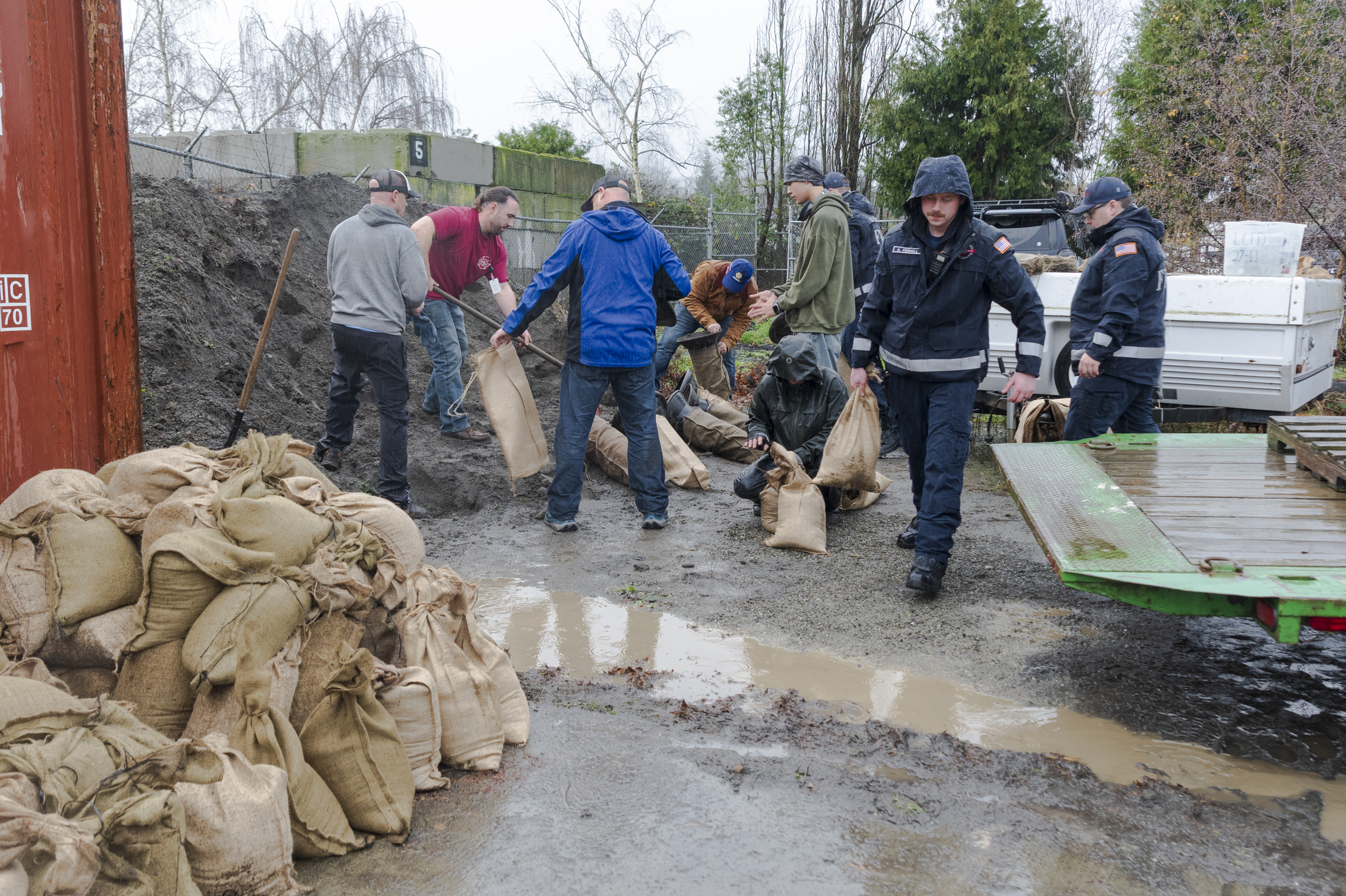
Skagit County Department of Emergency Management will help the public find available sand and sandbagging resources. Those in need of sandbags can reach out to DEM at dem@co.skagit.wa.us or by calling (360) 416-2090
To monitor road closures, visit the Skagit County road closure website here: www.skagitcounty.net/reporting/roadclose/
Residents should monitor forecasts and be ready for additional weather alerts. For health, safety, and preparedness information about floods, visit www.skagitcounty.net/Flood/Documents/FAW%20Insert%202025.pdf.
For updated river forecasts, please visit www.skagitcounty.net/Departments/EmergencyInformation/levels.htm or call the River Level Hotline at (360) 416-1404.
For more local emergency information, sign up for the emergency information listserv or follow Skagit County on Facebook @SkagitCountyWA. Call the Flood Hotline for general questions about this flooding event at (360) 416-2090. The River Level Hotline at (360) 416-1404 and www.skagitcounty.net/flood are updated frequently during events and can be resources for information as well.
Wednesday, 8:12 p.m.
At a community meeting at Skagit County Fire District 3 in Conway tonight, officials said they will begin patrolling the dikes at 6 a.m. Thursday, with crews supporting dike district commissioners and monitoring the Skagit River closely.
They acknowledged that the biggest risk to Conway (and to La Conner) right now is flooding if the dikes and drainage systems fail after the rivers crest, which could happen Thursday and Friday mornings.
The meeting followed an evacuation alert for Conway that was sent through the state Emergency Management Division’s texting program to the cell phones of people in the area to the surprise of local officials.
About an hour after the phone alert went out, SCFD3, Dike District 3 and Dike District 22 — which covers Conway and Fir Island — posted a clarification to Facebook:
“This was issued at a state level, not local level, out of an abundance of caution. The Conway and Fir Island area are not in immediate danger at this time and evacuation is at your own discretion.”
At the meeting, Skagit County Sgt. Brad Holmes reiterated that local agencies are not forcing anyone to evacuate, but strongly urged people to leave if they can — either tonight or tomorrow morning. He said the purpose of the state alert is to encourage those who are able to go early to do so, so limited local resources can focus on emergencies and rescues for those who remain. River height forecasts, he noted, have been changing and generally increasing throughout the day.
A Dike District 22 commissioner acknowledged the uncertainty, calling the Skagit “a very confusing river” and saying they are doing their best to prepare even though “we don’t know where to start” until the river shows more activity.
Darrin Morrison of Dike District 3 said they are standing up operations to patrol the levees on Fir Island and along the Skagit River from the east side of the river to the county line to the south. He said commissioners have been trying to think ahead and have done “tons of work over the last couple of years on the levees.”
“We feel confident we can hold a normal flood,” Morrison said, but emphasized that it’s a complex system, and it’s not automatic that the river will hit the projected 41–42 feet.
Residents were encouraged to evacuate if they are able, preferably by tomorrow morning, keep go-bags ready, and continue monitoring official updates.
Wednesday, 4:44 p.m.
Western Washington is in the middle of a powerful atmospheric river sequence, and rivers across the region are near historic levels. Evacuations are underway in parts of Pierce, Snohomish, and Skagit counties, and Gov. Bob Ferguson has declared a state of emergency. The National Guard is deploying to support impacted communities.

Here in Skagit County: Hamilton and Lyman are under evacuation orders, and everyone in the 100-year floodplain — including La Conner — should have go-bags packed and routes ready.
Key points for La Conner right now:
We got through the morning high tide without coastal flooding, so the seawater threat is low. But the river threat is serious — and the biggest risk is a dike/levee failure. County officials say a failure is likely given the record-level pressure expected on the system.
If a levee breaks, floodwater could spread across the delta toward town and flood roads around La Conner, potentially cutting off access to Conway and I-5. If that happens, the primary evacuation route would be over the Rainbow Bridge and out through the Swinomish Reservation toward Anacortes/Whidbey.
Public Works crews have staged 5,000 sandbags and 180 Ecology blocks, have pumps ready and are monitoring the channel closely. The Town has launched an emergency info page and is preparing Maple Hall and the Garden Club for shelter space. Schools and the Swinomish Tribe are closed Thursday and Friday.
This is a waiting game — and a high-stakes one. The Skagit River crests near Concrete early Thursday and near Mount Vernon early Friday, and La Conner remains at risk through the weekend, especially during the peak pressure window.
Wednesday, 11:17 a.m.
The Town of La Conner has posted a dedicated page for ongoing flood information and updates here:
https://www.townoflaconner.org/267/FLOOD-INFORMATION—Dec-2025
Town officials say they do not anticipate residents needing to evacuate at this time, but they’re urging everyone to stay alert and prepared in case conditions change.
Now that we’ve passed the morning high tide without issues in town, the primary threat shifts from coastal flooding to potential flooding if levees/dikes fail.
Officials also report that sensors in the Swinomish Channel are showing a higher concentration of fresh water in the top layer than usual — a sign the channel is already being affected by the river swelling upstream.
Important safety note:
Please do NOT walk along the dikes to check flood risk. Town officials stress this is dangerous, and foot traffic can put pressure on the dikes and increase the risk of failure.
Wednesday 9:21 a.m.
Skagit County is urging residents who live within the 100-year flood plain to be ready to leave as it braces for record-breaking flooding of the Skagit and Samish rivers.
Anyone living within the 100-year flood zone, which includes La Conner, is in Evacuation Level 2 and needs to prepare for sudden evacuation, according to the county’s Facebook updates and a map provided by the county. While the Swinomish Reservation is located on Fidalgo Island, some small areas by the slough are also included in the 100-year flood plain, as shown in the map.

The Skagit River is expected to crest — or reach its highest water level — at 47.72 feet at 4 a.m. on Dec. 11 (early Thursday morning) near Concrete, and 41.54 feet at 4 a.m. on Dec. 12 (early Friday morning) near Mount Vernon. The Samish River is expected to crest at 14.7 feet as of 10 p.m. on Dec. 10 (tonight) near Burlington, Skagit County reported on Facebook at 2:22 a.m. today.
According to the county, these mark a new record for both rivers: historic records for crests were 42.21 feet on the Skagit River near Concrete, 36.19 feet on the Skagit near Mount Vernon and 14.18 on the Samish River near Burlington.
In the Level 2 phase, prepare your evacuation route and destination, place your emergency kit in your vehicle, monitor social media and leave if you feel unsafe — or leave now if you need more time.
The kit should include enough water and non-perishable food for several days (for humans and pets), eating utensils, a can opener, a first-aid kit, prescription medications, hygiene products, cash, extra clothes and sturdy shoes, a flashlight and a whistle, pet supplies, matches or a lighter, phone chargers, personal documents, battery-powered weather radio and important contact phone numbers, according to the county.
If you have livestock: find a high-ground location for your animals, either on your property or elsewhere; plan several routes of escape; leave ASAP when evacuation order is given or leave earlier to beat roadblocks; ID your animals (if you do not already have ID for your animals, mark them using spray paint or grease pencil, or attach your contact information to a collar); consider food and medication for several days; leave the animals untied.
If your property is at risk of flooding but you don’t have a place to bring your animals, the following organizations may be able to help:
- Skagit Animals In Need: info@skagitanimalsinneed.org or via Facebook messenger
- Skagit Conservation District: 360-428-4313, skagitcd@skagitcd.org
- Cattlemen’s Association (for cattle only): 360-856-6266
- Buffy’s Animal Rescue: 360 708 2615 (call/text), banimalrescue@yahoo.com
– Shelter for 5 horses, alpacas, or similar.
– Shelter for 5-6 cows (no milking facility available).
– Grain and hay will be supplied by the Rescue.
If a Level 3 is issued, that means it’s time to leave immediately. Follow directions from 911, police, fire departments or local government agencies. Do not return home until officials determine it’s safe.
Stay updated by checking Skagit County’s Facebook page or the county’s Incident Information webpage.
Tuesday evening
A long, moisture-packed atmospheric river stretching from the Philippines to the Pacific Northwest is expected to drench Skagit County for days, and while La Conner is less exposed to river flooding than some upriver communities, local officials are warning residents to watch for coastal flooding as extreme high tides collide with persistent rain.
“This is a more prolonged weather event than we typically see — a once-in-every-few-years setup,” said Harrison Rademacher, a meteorologist with the National Weather Service in Seattle. “Rain continues through tonight, there should be a break Tuesday morning, then more rain arrives later Tuesday. From Tuesday through Thursday we’re looking at moderate to heavy precipitation.”
River impacts are now an urgent, upriver concern. The U.S. National Weather Service upgraded Skagit County near Concrete from a Flood Watch to a Flood Warning, effective 10:15 p.m. Monday night, until further notice. The Skagit River near Concrete is forecast to crest at 4 p.m. Tuesday at 32.62 feet, and then crest again at 10 a.m. Thursday at 36.98 feet.
The Skagit River at Mount Vernon is predicted to crest at 4 a.m. Wednesday at 32.04 feet, then peak again 10 a.m. Friday at 36.34 feet. All four crests are above major flooding thresholds — 32.5 feet in Concrete and 32 feet in Mount Vernon — making the main threat zone right now firmly upriver from Mount Vernon through Concrete and the upper valley.
The Skagit County Emergency Operations Center is working with partner agencies, along with cities and towns, to survey the county and close roads impacted by flood waters. Officials are urging people not to drive over flooded roadways and to practice “turn around, don’t drown.” Water can be deeper and faster-moving than it appears, presenting serious risks to drivers. To monitor road closures, residents can use the county’s road closure map and follow all posted barricades and warning signs.
Residents should monitor forecasts and be ready for additional weather alerts. Based on the current forecast, those living in flood-prone areas should take action to protect their homes, families and livestock from floodwaters.
In La Conner, though, the greater worry is still what happens where sea and sky meet.
“We’re actually pretty well-protected from river floods,” La Conner Fire Chief Aaron Reinstra said Monday. “Ours is the coastal floods.”
Reinstra said he has coordinated closely with the Town’s Public Works Department and Skagit County Department of Emergency Management to build a five-day outlook using local monitoring systems and state and federal forecasts.
He said La Conner has rarely seen major flooding in his decades living in town. But this season’s king tides are unusually frequent and high, tightening the window for error if heavy rain and wind pile water onto the shoreline.
“The tides this year are pretty extreme,” Reinstra said. “We have 17 days this month and 19 next month of 11-foot-7-inch tide height. As long as the stars don’t line up like they did a few years ago, we should be okay.”
The fire department and public works are using a local tidal-surge model that tracks predicted tide height in real time. Reinstra said crews will begin monitoring about an hour before peak tide.
“If it’s supposed to be 11-6 at 9:30, we’re watching at 8:30,” he said. “If it goes up faster than expected, we’ll be on standby. If we get a warning that it is going to flood, volunteers will be out sandbagging.”
Residents who want to prepare can pick up free sandbags and sand from the La Conner Fire Department, Reinstra said, but they must fill the bags themselves.
Across the broader region, forecasters say the atmospheric river’s rainfall remains the biggest threat. Saturated soils increase the risk of landslides and debris flows in steep terrain and on burn scars, and river flooding is possible as multiple waves arrive.
Rademacher said the first round of rain continues through Monday night, followed by lighter rain Tuesday and then a stronger push late Tuesday into Wednesday, with rain persisting through Thursday. Winds gusting 30 to 35 mph Monday are expected to ease overnight, with another breezy period Tuesday night into Wednesday peaking around 20 to 25 mph. Temperatures will be mild for December, with highs in the upper 50s and lows in the mid-40s.
Officials urged La Conner residents to keep an eye on tide forecasts and local alerts through midweek, as the prolonged storm and high-tide cycle overlap.
Kari Mar is the editor and publisher of La Conner Community News.
